4. Where
Consider the general actions which you can take:
Identify locations in your local area which have extremely high social vulnerability and extremely high disadvantage to different hazards using the Climate Just Map tool. These places are a good place to start when considering developing responses as they indicate a local area which has challenges in terms of the potential for being affected by an event like a flood or heat wave and also the likelihood for the social impacts of those events to be greater.
Identify locations in your local area which have different profiles of socio-spatial vulnerability and disadvantage using the Climate Just Map tool. A local area may not be highlighted as having extremely high socio-spatial vulnerability. However, this does not necessarily mean that no action is required. For example, the area may still be associated with extremely high values in individual indicators or elements of social vulnerability, such as inability to prepare, recover or respond. Finer scale flood data have reduced some of the problems with the original data, but even in areas with very low overall social vulnerability, there is still a high likelihood that there will be some vulnerable people who require assistance in order to avoid being severely impacted. Different actions will be appropriate for each of these different neighbourhood types (see Figure 10).
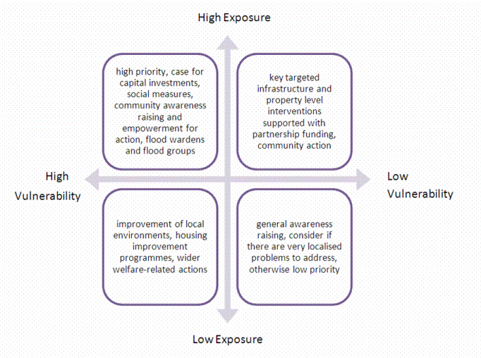
Figure 10: Actions related to different climate disadvantage types.
Develop multi-dimensional assessments of social vulnerability and consider how people and communities can face multiple challenges which may be important for building resilience. Multi-dimensional assessments take account of different causes of uneven impacts, different geographical scales, different time-frames and different perspectives of the issues. Adaptation can be made more effective by taking account of differences in the sensitivity or susceptibility to harm of people and communities, differences in abilities to prepare for, respond to and recover from extreme weather events, and differences in the physical characteristics of neighbourhoods themselves. Each of these dimensions or characteristics and the individual indicators behind them can be explored using the resources in the Map tool. Part of this activity involves considering finer scale geographical data and data for more recent datasets which is held within your organisation or partner organisations. See the examples of how to interpret the data for local areas.1
Benefits can be gained from mainstreaming climate adaptation measures and messages into the activities of agencies working with vulnerable groups such as social care providers. See suggested broader actions you can take to improve resilience such as those associated with partnership working, raising awareness and community engagement and empowerment. Examples of actions that address social vulnerabilities at the local authority level could include the following:
- addressing institutional routines and habits of places such as in residential nursing homes and other places which provide care. See for example Advice for care home managers and staff: supporting vulnerable people before and during a heatwave
- maintaining and improving social care for the elderly in their homes, using for example telecare solutions such as Bournemouth Borough Council's Careline services.
- the use of public spaces such as post offices and libraries in which members of the local community can meet and which might act as safe spaces during floods or cool spots during heatwaves, and making other spaces, such as schools and local businesses, available to the public in the event of a climate hazard. See an analysis of provision of social infrastructure in relation to vulnerable groups in Greater Manchester;2
- fostering community support groups and engaging and empowering local communities in decision making about responses to flooding. See the sections on community engagement and awareness raising and partnership working.
Identify the magnitude and likelihood of hazards associated with the changing climate, including flooding and heatwaves.
- Use the measures of flooding and high temperatures in the Climate Just Map tool to compare patterns of socio-spatial vulnerability with patterns of potential exposure to flooding and heatwaves.
- Make reference to the updated maps of flood disadvantage in the Climate Just Map tool which take account of climate change.
- Draw on existing risk assessments, adaptation tools such as the UKCP09 projections and the UKCP18 (which will update UKCP09 over UK land areas and sea-level rise, giving greater regional detail) as well as other local information (for example following the UKCIP Local Climate Impacts Profile (LCLIP) process). See an example LCLIP for Greater Manchester.
- Examine the impacts of extreme weather events including their location, timing, costs and the effectiveness of responses by recording local experiences. Record social as well as economic impacts associated with events and consider longer-term and not just immediate impacts.
Review the case studies section to see what others have done. In particular see the Further Resources (Section 6, above) for information about work carried out by:
- JBA consultants on using the Climate Just data to support adaptation planning in Wigan Council. Their work makes suggestions about how you might use the data for supporting the development of adaptation plans and other responses.
- Hampshire County Council which has developed its own version of the data in this portal. This is supported by a ‘how to’ document which explains some of the technical details which may be suitable for data specialists within your authority.
- Leeds City Council which has developed an online mapping portal covering multiple indicators of social vulnerability.
Consider specific actions to help build resilience for the people and communities that you identify.
- See Who is vulnerable? to find out more about actions associated with particular socially vulnerable groups, recognising it is the combination of characteristics which can determine the most extreme social vulnerability.
References
- Example pen-pictures of local areas (in User Guide, Section 2)
- Kazmierczak, A (2012) Heat and Social Vulnerability in Greater Manchester, a risk-response case study

Built by:
![]()
© 2014 - Climate Just
Contact us